The Owners Agent and I spent the recent festivities in Nova Scotia whilst Vagabond remained in safely in the shed beside the cattle. I assume she is still there for there hasn't been time to see.
You would think it a short flight from London to Halifax but direct flights were not available. The route offered was via Montreal and this left me with time on my hands at 38000 feet above the North Atlantic. .
I fell into a dream. Where and when do we resume the voyage? Do I trail her back to Balvicar (incidentally, Balvicar got a mention in PBO the other month - did you see it?) to then continue clockwise as before, so ending our journey back at Burnham on Crouch - or shall I trail her to Burnham to turn left every morning so that we arrive at Balvicar some time in the late summer? If we did the latter, Vagabond could rest at Balvicar for following winter and be ready for a cruise of the Western Isles in 2014. I find the idea of meeting ourselves halfway and the following cruise quite tempting.....
My wool gathering turned into a bit of a muddle: do we need a sort of cruising sheet? Does that need a boom? How about a duck board in the cockpit? Or some sort of extension to my legs so that I can more easily stand on the lee side of the cockpit when heeling to the breeze? Perhaps I need built up shoes! And then there is the idea of a piece of wood to cover over the outboard well so that there is less slop and gurgle when going downwind. Do we need more solar cell capacity - it never was really tested this summer as we "parked" in marinas so often. Do I need to replace the wind speed and direction vane that was shaken off the mast. I hear rumours of a new aerofoil shaped mast - will that be stiffer than the current one and less liable to vibration. Oh yes, we need to seal the duct that brings the gas pipe into the cabin from the gas locker. Does the A frame help when lifting the mast? And then there is the matter of charts and pilots - do they need updating? And I though there was a broken strand in the fore stay. There will be some long stretches on the East Coast - could an autopilot be made to work? Or do I try to persuade one of my long suffering friends to do a couple of overnight sails with me? The outboard needs servicing. The centre board lifting blocks need lubricating. The rudder pintles need examination. The scuffs on the centre board and rudder need epoxying from the odd bump or two that they had - (that's an admission that's just sneaked out).
The list goes on and on.
Nova Scotia was cold, with snow. Apparently it rained a lot in the UK. A bit like last summer really. I gather the met office is laying bets on the Jet stream being South again in the coming summer. Looks like an interesting year ahead.
Sunday, 30 December 2012
Saturday, 1 December 2012
Dover to Eastbourne revisited
Here's the track taken by Vagabond in the leg from Dover to Eastbourne last May.

I hope it is fairly self explanatory
Thursday, 29 November 2012
Spray Hood adjustment
As originally fitted, the spray hood frame was mounted on the top rail of the gunnels. This meant that the crew (or owner - usually one and the same) had to tread all over the bottom of it when a hand was needed to go forward of the cabin. Clipping on to go forward was made difficult and the centre mooring cleat was also hidden from view. The owner considered this not particularly satisfactory.
 |
| The end result |
On a wet day (there have been many this month) the owner was visiting Vagabond in her barn and thought it would be an appropriate time to resolve this issue. The spray hood was removed and the frame pivots undone. After an hour or so "fiddling about" and a discussion with the boat builder, it became clear that the pivots could be repositioned onto the cabin sides.
Appropriate wooden blocks were cut and two were glued onto the inside of the cabin wall (out of sight in the internal locker area). Whilst the epoxy was setting, the two external blocks were spruced up and varnished before being screwed through the cockpit side on the inner blocks. Al that remained to do was screw the pivots to the blocks and refix the frame.
OOPS. The frame wouldn't fold flat, because the frame shape was an even semicircle and it fouled the cabin roof. The owner recalled his pipe bending skills and eventually shaped the frames into graceful D's to provide the necessary clearance.
More tracks to be published soon. I bet you can't wait!
Friday, 2 November 2012
Ramsgate to Dover
The Owners Agent and I are now of no fixed abode. On Monday last we moved out of the house that had been the family home for the last 39 years and are now in a "holiday let" waiting for the purchase of our next home to go through the various legal hoops. We have frequented charity shops and ebay pages to "downsize" our household effects: the remaining items are located in various storeroom and friends houses.
Suddenly I have time on my hands to paint and varnish parts of Vagabond, culitvate the (newly acquired) allotment and review our exploits last summer.
Today, it's the track of the passage from Ramsgate to Dover.
 The wind was astern and you can see that we gybed a few times on the way!
Suddenly I have time on my hands to paint and varnish parts of Vagabond, culitvate the (newly acquired) allotment and review our exploits last summer.
Today, it's the track of the passage from Ramsgate to Dover.

Tuesday, 23 October 2012
Moving and Navigating
As the dedicated reader may have gathered, the Owners Agent and I are in the process of moving house. And what a process. We know when we are moving, we know where we are going immediately and we know where we want to be in the longer term (not where we're going to be immediately). What we don't know is when we'll be at the end point.
Just to set your mind at rest, we are not moving into Vagabond whilst she is parked in the barn at Kings Ash Farm. (Not ever, I hear the Owners Agent asserting very firmly.)
As a bit of light relief, I have discovered that I have recorded most of the track that Vagabond follwed this summer and that I can display them on a PC. So now you can be amazed by this technology as I publish these tracks over the next few weeks. You can re-live each leg and refer back to the blog of the day!
The third snag is that the Ipad does not communicate with any other instrumentation - I daresay you could do it using the wireless interface but that is (a) beyond my competence and (b) would use even more precious amps.
So I have a second GPS, the Garmin 620 already discussed. This serves as a back up to the IPad, as it takes its power from the main batteries and, as I have discovered, records the track.
It talks with the VHF, to give it the GPS details for the dreaded DSC Mayday call, and also listens to the radio information on AIS data from other ships. When the radio identies a potential "target", the GPS displays them and it shouts at you if they are dangerous. Usually this warning is very pessimistic and can be ignored once one has identified the target although it did make me wake up when one of those fast catamaran ferries snuck behind us near Poole.
As originally fitted, there was a TackTick wind sensor at the mast head, communicating with a Tactick display. This also receives Sog and Cog from the GPS so can show both relative and true wind speed and direction. It's blank in the photo above, showing that the picture was taken after the sensor had been blown off.
Finally, there's a TackTick depth display. On a couple of occasions (when sailing very quickly) is has shown spurious results.
The ship batteries are topped up by a couple of solar panels mounted on the poop. I have not yet exhausted the batteries during a cruise but have only been away from shore power for a couple of days at the most.
Just to set your mind at rest, we are not moving into Vagabond whilst she is parked in the barn at Kings Ash Farm. (Not ever, I hear the Owners Agent asserting very firmly.)
As a bit of light relief, I have discovered that I have recorded most of the track that Vagabond follwed this summer and that I can display them on a PC. So now you can be amazed by this technology as I publish these tracks over the next few weeks. You can re-live each leg and refer back to the blog of the day!
 |
| The "Nav Station"- the scribble on the right is my passage plan of the day. |
Firstly, though, a word on the instruments fitted aboard Vagabond. This photo shows the "Nav station" of Vagabond swung into the "under way" position. When at rest, the board can be swung into the cabin. In the middle of the trip (crossing from Holyhead to the Isle of Man to be exact) I realised that this arrangement was a bit dangerous - in really rough weather there is a real risk that the cabin could be flooded by a wave coming down the companion way.
I use Navionics software and charts running on my Ipad2 mounted in a waterproof case (the blue rectangle in the photo) as the main source of navigation information. The Ipad2 includes a GPS and the Navionics software is excellent. There are three snags with this arrangement.
The first is that I have to rely on the internal Ipad battery power whilst it is in the waterproof case and this can be marginal if it's left on all day. I overcome this by making sure the Ipad goes to sleep after 10 minutes of operation (as it is in the photo) but this does mean that you can't record a track as the GPS loses position when the Ipad is asleep.
The first is that I have to rely on the internal Ipad battery power whilst it is in the waterproof case and this can be marginal if it's left on all day. I overcome this by making sure the Ipad goes to sleep after 10 minutes of operation (as it is in the photo) but this does mean that you can't record a track as the GPS loses position when the Ipad is asleep.
The second snag is that it is sometimes difficult to see the screen in very bright daylight. I overcome this by having the Ipad mounted on a quick release strap (Velcro!) so that I can take it off the board and put it into a shaded spot to read if necessary (it is tied on too!)
So I have a second GPS, the Garmin 620 already discussed. This serves as a back up to the IPad, as it takes its power from the main batteries and, as I have discovered, records the track.
It talks with the VHF, to give it the GPS details for the dreaded DSC Mayday call, and also listens to the radio information on AIS data from other ships. When the radio identies a potential "target", the GPS displays them and it shouts at you if they are dangerous. Usually this warning is very pessimistic and can be ignored once one has identified the target although it did make me wake up when one of those fast catamaran ferries snuck behind us near Poole.
As originally fitted, there was a TackTick wind sensor at the mast head, communicating with a Tactick display. This also receives Sog and Cog from the GPS so can show both relative and true wind speed and direction. It's blank in the photo above, showing that the picture was taken after the sensor had been blown off.
Finally, there's a TackTick depth display. On a couple of occasions (when sailing very quickly) is has shown spurious results.
The ship batteries are topped up by a couple of solar panels mounted on the poop. I have not yet exhausted the batteries during a cruise but have only been away from shore power for a couple of days at the most.
Monday, 15 October 2012
Still here
Hello, dear reader.
No doubt you are wondering about the deathly silence on this blog, as it slips down the google lists.......
It's been a bit quiet on the Vagabond front on the last couple of weeks. I think she's still under her dust sheet, in the barn. She was last week, when I anointed all the scuffs and blemishes on the rubbing strip with varnish (well what are rubbing strips for, if not to become somewhat scruffy over a season?).
That's not much to show for a couple of weeks but my mind has been elsewhere. Literally for an hour or so one mornign a couple of weeks ago, although a supsequent scan assures me that I still have one ( a mind, that is) and the neurologist says it's nothing to worry about.
Meanwhile, the mind has been on line, the Owners Agent and Ihave been concentrating on this downsizing activity. This is not something we recommend after living in the same place of 39 years (and after recently acquiring a boat) One skip load has gone from the garage. A number of pieces of furniture have been ebayed for a song and we had a party last weekend at which we managed to give away a few knick knacks. A self store room has been filled and there is still more to go.
We become of no fixed abode as of two weeks hence - the Owners Agent refuses to take up my offer of B & B on Vagabond, so we are in a holiday let in the middle of Buckinghamshire (and winter approaches....).
Chin up - things are worse at sea (as my mother always used to say.....)
Friday, 21 September 2012
Boat Show Edition
Well, dear reader, I've just returned from the boat show at Southampton. A new wind speed instrument has been obtained, so in the next part of the voyage I can expand the nerd index of the posts and blether on about real and apparent wind speeds (until the whirly thingy falls off the mast again). Shopped out, I spent a few hours on the Swallow Boats stand, trying not to put off potential customers by explaining our progress so far (and promoting this blog!)
At times it seemed to be a Swallow Boats Owners club meeting. Hardly an hour passed without a current owner of Bay Raider or Bay Cruiser turning up and chatting with Matt Newland (the boss) to find out what's new. (The real one is called the Swallow Boats Association and it has it's own web site and forum http://www.swallowboatsassociation.com/).

The visitors seemed really interested in our exploits and, judging by the "hits" on the blog in the last couple of days, many of them (you?) have found us on the web!
Several urged me to call into see them up on my way round the rest of the UK next summer, including Ian Richardson, of Stromness, the designer and builder of this delightful wooden boat based on a traditional Orkeny working boat.
The sun shone, the breeze wafted past and several potential new owners were shown over the Swallow Boats on display.
I discovered that I had withdrawal symptoms and went to have a look at Vagabond today.
Despite being in a barn, Vagabond has become very dusty. I have now covered her with a large tarpaulin that I happened to have available. I've also made an A frame out of a couple of aluminium tubes from my old hang glider.* The theory is that this should make it even easier to lift and lower the mast by giving a better mechanical advantage** when hauling the mast up from the horizontal "derigged" position. I'll let you know next spring if it works!
* Airwave Magic 4, built in 1988 and scrapped in 2003 with about 100 hours on the airframe.
**technical term - the intention is that the rope used to hoist the mast will be led round a pulley on the top of A frame, thus pulling the mast UP rather than sideways.
Friday, 14 September 2012
Nothing to report
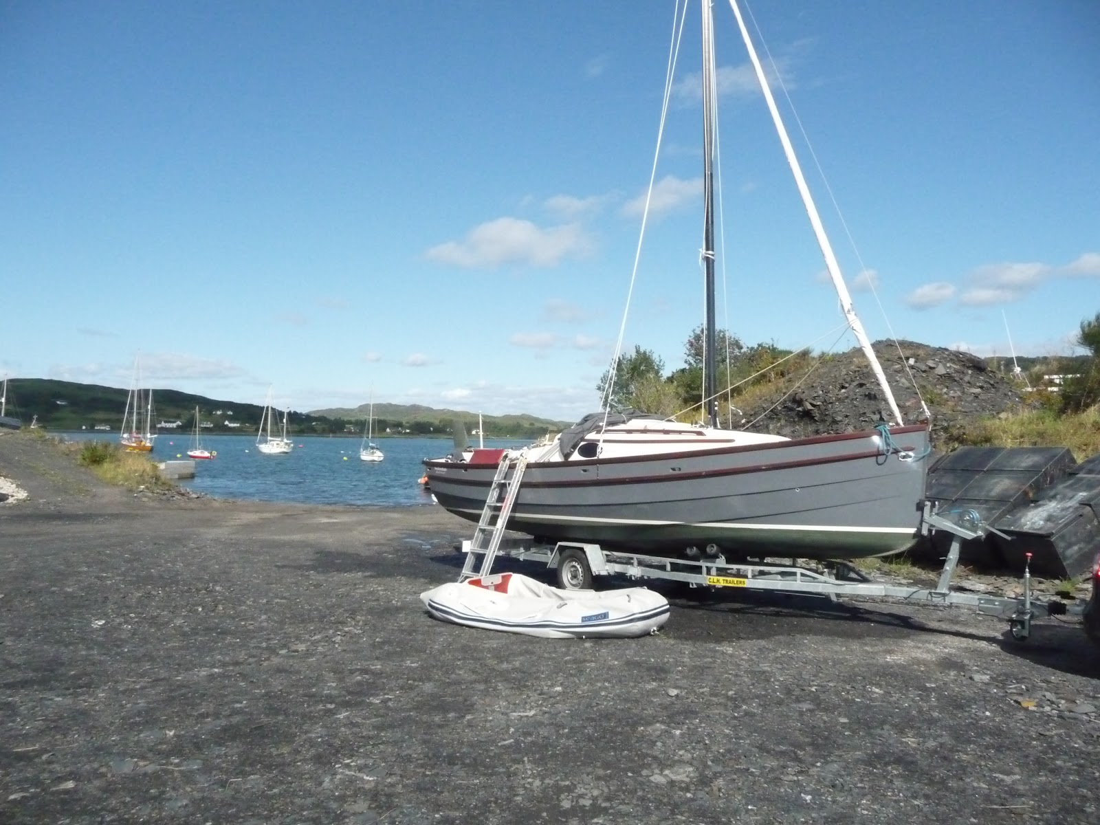
Vagabond is now under a roof in a barn not far from my home . Stripped of sails and mast she looks a bit dejected parked alongside cement mixers and fork lift trucks.
The rail and rubbing strip need varnishing, the rust streaks need cleaning off and Freddie needs to be serviced. At least I can do these winter jobs out of the worst of the weather. But in my usual style, I'm putting them off.....
Instead, I'm off to the Southampton boat show next week. The owners agent has said I can go and that she wants no part in it.
Who knows what will happen?
Tuesday, 4 September 2012
Winter Quarters
My readers (I now realise that there are at least four of you) will remember that I had left her on a mooring at Balvicar on Seil Island, just south of Oban. I was on a three line whip to be home for a wedding. With the help of the local bus, Scotrail and Virgin trains (not to mention the Owners Agent, who met me at a local station late at night) just made it.
The following week, I extracted the trailer from the local farm and headed north. The M6 was trouble free, the Vikings' widow kindly gave me lunch, and the we arrived in Balvicar late on the Wednesday evening. The trailer was abandoned in the boat yard and I took the car away to fill it with fuel for the trip south.
The following afternoon, when the tide was rising, Doris took me out to Vagabond, Freddie was fired up (first pull even though he had been ignored for a week) and I brought Vagabond into the slipway entrance, to tie up alongside the jetty. The car and trailer were manoeuvred into position on the loose surfaced slipway. I pulled Vagabond so that her nose was nuzzling against the trailer rollers. Then the wind took charge and Vagabond was blown diagonally across the trailer centre line.
Much fiddling about with the anchor over the stern corrected this. Meanwhile the tide rose; the sea lapped around the trailer and approached the tow car. I unrolled the winch tape and attached to Vagabonds' nose ring, the strain was taken up and I slowly pulled her out of the water onto the trailer. After what seemed like about 10 minutes of winching, she was sitting on the trailer and I was seriously pleased that I had emptied the ballast tanks on the last sail.
Now came the task of moving the car and trailer up the slipway before both were engulfed by the tide. The slipway surface was loose slate. The tow car has front wheel drive and the first attempts to get the ensemble moving were disasters. The wheels slipped, the anti skid system came into play and the whole lot just stopped. I reasoned that the trailer wheels might have become embedded a bit in the surface, so uncoupled the trailer and moved it back (down slope) a bit (I couldn’t move it up the slope). Pulling in the stern anchor seemed to be a good idea too....
 |
| Out of the water with Doris deflating! |
When I re-coupled the trailer to the car, I turned off the anti skid electronics and, with my heart in my mouth, gently turned on the power (it’s an automatic). The wheels slipped and then gripped and, with some wheel slip, we moved up the slip away from the water.
She’d been in the sea since May and was weed and other growth free – the CopperCoat, though green, clearly did what it said on the tin.
Two hours later, Vagabond had been de-rigged, Doris deflated , and we were on our way south. Planning the journey was a bit like planning one of the voyages – it was all a question of timing. Timing to miss the Glasgow rush hour. Timing to get to motorway services and the overnight stop where trailers could be accommodated that meet the drivers needs (Teebay, on the M6, was the first stop). Timing to miss the Manchester and Birmingham rush hours.
It all worked well; the M74 and M6 were clear and Vagabond was in the barn in Buckinghamshire by 2pm on Friday. I could go home and get ready for the next wedding on time. Why do all these things come together?
500 miles 10 hours VW motor all the way!
Thursday, 23 August 2012
Balvicar Island of Seil. Pause button pressed.
Monday morning showed a clear sky. The coastguard weather report promised S / SE winds at force 3 -4 and smooth seas in sheltered waters with possible thrunderstorms later. We were headed further north east, up the Sound of Jura and then branching off to starboard. If you go and look at a map of this bit of Scotland, you will see that the Sound of Jura runs roughly NNE and is bounded by Jura on the west and the mainland on the east. The mainland is broken into a number of finger like peninsulas, each with a string of small islands at its southern tip and with sea lochs in between them. At the head of the sound a number of islands block the way into the Firth of Lorne. As the tide rushes up the sound, the water is forced between these islands giving rise to tidal races between them.
One of these is the legendary Corryvreckan and another is known as Dorus Mor.
Our destination for today is Balvicar at the head of the Seil Sound, itself at the head of Loch Shuna, a sea loch between two of the Peninsulas*. The Vikings' daughter has a cottage nearby and is on good terms with the owner of the boatyard there. It will be a good place to leave Vagabond whilst I go home and cut the grass (etc).
I climbed onto the boom again to make a few phone calls. Yes the boatyard can let me have a mooring for a couple of weeks. Yes the cottage is available, the neighbour will let me in.
We have to negotiate the Dorus Mor to get there so all I have to do now is work out the tide times...
I find conflicting advice.
One book recommends passage times that change depending on whether it's neaps or springs. Others make reference to High Water at Dover. All say the best time to go through is at slack water and the speed of the current suddenly increases an hour after it. I plump for the HW Dover option and realise we have to leave now to be there in time.
I had planned to creep out of the north exit of my lair - the chart plotter seemed to think there was a way through, as did the Clyde Cruising club but when I let go of the buoy, Vagabond had other ideas and only wanted to go out the way we had come in. So we did.
Out into the Sound and up with the sails. We turn north and waft up towards the Dorus Mor. The wind is light and dead astern; I try to set the jib in a Goose wing. It just flaps from side to side as we drift along. There's plenty of time, isn't there. A yacht appears ahead and seems to be going the same way.
Another yacht motors down a loch to the right and swings round into the Dorus Mor. It seems to get through easily enough, so it must be slack water there. At this rate we're still an hour away - so we'd better get a move on. Freddie gives us a helping push and we arrive at the entrance to the Dorus Mor in the company of two other yachts, all motor sailing like us.
The yacht behind was a 45 ft Halberg Rassy and the helmsman was itching to overtake Vagabond as we went through the Dorus Mor passage. He was edging to pass us on our starboard side- the snag was that I wanted to turn that way as soon as we got through the passage, to run up Loch Shuna. I could have found the fog horn and blown one blast. ('I am turning to starboard') but he wouldn't have heard it (and if he did, he would have had to go and look up what it meant), so I put my hand out like a cyclist! He understood, waved and crossed our stern to pass on the other side.
The water in Loch Shuna was flat calm. The sun shone. The wind was still behind us and we now had plenty of time and a long run ahead of us. I pumped out the water ballast and set the jib into a stable goosewing. Vagabond accelerated to just over 6.5 knots.
After we had passed Shuna Island, we needed to veer a bit to port to cross a bit of open water and then head up Seil Sound to find the anchorage at Balvicar. The wind veered with us and we stayed goosewinged all the way until just before the anchorage when we came into the wind to drop the sails. Now I remember what is is I like about sailing in this part of the world.
Clouds gathered around us as we came into the anchorage. We found a mooring buoy and had just made fast to it when the rain started. It threw it down. This was one of the thundery showers that the met had forecast. I hastily put up the spray hood and huddled under it for about 20 minutes. This reminded me of the downside of sailing in this part of the world.
I took the opportunity to read the log.
17.7 miles in the day, at an average speed of just over 4 knots.
It may be time to press the Pause button for longer than a fortnight......
*Peninsulae for the Latin scholars amongst my readership
 |
| The Corryvrekan runs through this gap |
Our destination for today is Balvicar at the head of the Seil Sound, itself at the head of Loch Shuna, a sea loch between two of the Peninsulas*. The Vikings' daughter has a cottage nearby and is on good terms with the owner of the boatyard there. It will be a good place to leave Vagabond whilst I go home and cut the grass (etc).
I climbed onto the boom again to make a few phone calls. Yes the boatyard can let me have a mooring for a couple of weeks. Yes the cottage is available, the neighbour will let me in.
We have to negotiate the Dorus Mor to get there so all I have to do now is work out the tide times...
I find conflicting advice.
One book recommends passage times that change depending on whether it's neaps or springs. Others make reference to High Water at Dover. All say the best time to go through is at slack water and the speed of the current suddenly increases an hour after it. I plump for the HW Dover option and realise we have to leave now to be there in time.
I had planned to creep out of the north exit of my lair - the chart plotter seemed to think there was a way through, as did the Clyde Cruising club but when I let go of the buoy, Vagabond had other ideas and only wanted to go out the way we had come in. So we did.
 |
| Disturbed water through the Dorus Mor |
Out into the Sound and up with the sails. We turn north and waft up towards the Dorus Mor. The wind is light and dead astern; I try to set the jib in a Goose wing. It just flaps from side to side as we drift along. There's plenty of time, isn't there. A yacht appears ahead and seems to be going the same way.
Another yacht motors down a loch to the right and swings round into the Dorus Mor. It seems to get through easily enough, so it must be slack water there. At this rate we're still an hour away - so we'd better get a move on. Freddie gives us a helping push and we arrive at the entrance to the Dorus Mor in the company of two other yachts, all motor sailing like us.
The yacht behind was a 45 ft Halberg Rassy and the helmsman was itching to overtake Vagabond as we went through the Dorus Mor passage. He was edging to pass us on our starboard side- the snag was that I wanted to turn that way as soon as we got through the passage, to run up Loch Shuna. I could have found the fog horn and blown one blast. ('I am turning to starboard') but he wouldn't have heard it (and if he did, he would have had to go and look up what it meant), so I put my hand out like a cyclist! He understood, waved and crossed our stern to pass on the other side.
The water in Loch Shuna was flat calm. The sun shone. The wind was still behind us and we now had plenty of time and a long run ahead of us. I pumped out the water ballast and set the jib into a stable goosewing. Vagabond accelerated to just over 6.5 knots.
After we had passed Shuna Island, we needed to veer a bit to port to cross a bit of open water and then head up Seil Sound to find the anchorage at Balvicar. The wind veered with us and we stayed goosewinged all the way until just before the anchorage when we came into the wind to drop the sails. Now I remember what is is I like about sailing in this part of the world.
Clouds gathered around us as we came into the anchorage. We found a mooring buoy and had just made fast to it when the rain started. It threw it down. This was one of the thundery showers that the met had forecast. I hastily put up the spray hood and huddled under it for about 20 minutes. This reminded me of the downside of sailing in this part of the world.
I took the opportunity to read the log.
17.7 miles in the day, at an average speed of just over 4 knots.
The rain eased off enough for me to inflate the dinghy and go ashore to report to the boatyard. Over a cup of tea I outlined my plans and I returned to Vagabond to properly put her to bed for a couple of weeks and to take off her the stuff I needed to take home.
It was then off to the cottage, a hot shower and a real bed. Next morning I was on the way home, by bus on the Bridge over the Atlantic and train from Oban to the south. It took 13 hours, door to door!
Our total mileage so far is just over 1000.
I had reached my (revised) goal for the year (Oban by September).
Activity at home on the house move front looks like it's hotting up.
I had reached my (revised) goal for the year (Oban by September).
Activity at home on the house move front looks like it's hotting up.
 |
| Vagabond on the buoy in Balvicar bay |
It may be time to press the Pause button for longer than a fortnight......
*Peninsulae for the Latin scholars amongst my readership
Wednesday, 22 August 2012
The Sound of Jura
Never mind what it says on the blog posting, think Sunday 19th August. We are in Port Ellen, on the Island of Islay, getting ready to go north into the Highland and Islands of Scotland. The forecast is for wind SE to S, force 3-4, perhaps 5 later.
Several other yachts are also getting ready to depart. On Schiehallion, a forty five footer, the barbecue is being stowed away. They're off to the south. The skipper of Wild Thing is trying to pass on the fresh scallops they were given by a fisherman before thet "go round the corner" for lunch. Both leave before us and I see them motoring out of the bay.
If we go now, we'll have a weak "foul tide" for an hour or so, but then it will woosh us north, up the Sound of Jura. We're aiming for Carsaig, an anchorage on the east side of the sound, well protected from the East and South.
Freddie pushes us out into the bay - there's a light wind from South. The sails are hoisted and we sail out of the bay and tack off eastwards, along the south coast of Islay. Distillery after distillery passes by as we cruise east a couple of miles off the coast in a calm sea. I suppose I should have stayed for a day and had a tour or two - never mind, there are distilleries on Mull and on Skye.
This area is littered with rocky bits and small islands, so I have to keep a sharp look out and eye on the chart plotter to make sure we are not running into danger. The wind dies and the tide starts to push us west again. I pull Freddie into life and we motorsail east again. We pass Tarr Skeir, the southern most of of the rocky islands and turn north east, towards the Ardmore Islands that mark the entrance to the Sound of Jura. Here we turn more to the north.
There's a yacht coming up behind us. It's sails are full and it's leaning in the wind. Suddenly the water becomes more agitated. Three foot swells roar round the Islands from thewest. The tide has changed and is now coming in from the Atlantic, pushing us northward. The wind arrives too and we are soon scurrying along at 7 knots. The yacht astern passes the islands and turns west to run up the Sound of Islay (that channel between Islay and Jura). We cross the meeting place of the two sounds, pass Gigha aIsland some miles away to our right and follow the coast of Jura, keeping a couple of miles off it. Ith a following sea a routine is rapidly established - stern rises and is pushed to the right as a wave overtakes us. Push tiller right to keep on course. Wave passes underneath us and then pushes the bow up and to the left. Pull tiller to the left to compensate. It's quite hypnotic.
I'm woken from the trance by the emergency tone shrilling out of the VHF.
A MayDay. Press the button to silence the alarm and turn up the volume to listen to the unforlding story.
Belfast Coastguard takes control 'Belfast Coastguard calling Station calling MayDay over". There's a bit of silence - I assume the vessel in trouble is replying and we can't "hear" the response. The next I hear is 'Mayday Schiehallion, Schiehallion, Schiehallion, this is Belfast coastguard, please spell the name of your vessel' . Schiehallion! That's the forty plus footer that had left Port Ellen just before us. It appears they are taking in water. One yacht and two commercial craft respond to the call, a lifeboat is on the way and the yacht is soon alongside the casualty. At this point, Clyde coastguard want to give out the new eather forecast, so I give up my voyeurism and listen to the forecast.
The sea pattern changes and becomes confused as the Sound of Jura narrows and I make a mistake. I should have headed closer to one or other coast but stay in mid channel. Soon we are in a very rough sea, being pushed hard by wind and tide. I take in a reef and things calm down. And so we carry on. The Paps are modestly covered by cloud.
The wind dies down but the current is pushing us to port, towards Jura and we want to head towards the mainland. I try to shake out the reef but the main hailiard is caught round something at the top of the mast. We'll have to stay as we are until we can get into calmer water; as it is, the 10 minutes we spent drifting whilst trying to sort things out have pushed us back towards Jura.
I turn Vagabond towards the mainland shore, more concerned with finding some calmer water than with making progress to the north and we close to within a couple of cables* of the mainland shore, where things are calmer and I can sort out the haliard and hoist the full main.
Order and confidence restored, I remember to switch the radio back to channel 16, the emergency channel. The hue and cry over Schiehallion has died down, so I assume all ended happliyd .
The wind gets up a bit and Vagabond surges north east again, as I search the coast for the entrance to Carsaig. A large yacht is motoring towards us and turns in ahead of us. We follow and I can see there were already two other yachts here and the one ahead of us has pinched the most protected of the spaces left. Never mind, we need less water than she does and can get nearer the shore. I also see that some buoys have been positioned in the anchorage. They weren't here last ime; one is free. That will do nicely - but it is a long way from the beach and the road to the pub.
Within 20 minutes we're secure to the buoy and the wind has gone completely.
We've done 36 miles today in 7hr 30min (2 hrs were under power).
A large rib rushes around the anchorage and persuades the other yacht to move to another bay.
We're snug where we are, there's three metres of water under the boat so we won't touch the bottom as the tide falls. I can't be bothered to move to the vacant space, nor to inflate the dinghy, row to the beach and walk to the pub (and back - besides which, last time I was here it was shut...)
I stand on the boom to find a mobile signal to report progress to the Owners Agent and to find out if we're homeless yet (no).
I don't trust myself up here with the Ipad so we'll have to go without a weather forecast until tomorrow. It doesn't look like it will rain overnight so I'll leave the tent down just in case I have to get on deck in a hurry.
I make a three course meal - soup, ham and avocado salad, followed by biscuits and cheese, accompanied by a glass of Rjoca, followed by coffee and an after dinner chocolate (well actually a mini Twix, if you really must know), wash up and turrn in for an early night.
The tide won't turn north until midday tomorrow; I wonder where it will take us?
Whereever we go, we only have to do another 10 miles or so and we will have clocked up 1000 since we left Burnham on Crouch.
We must be nearly half way.
* A cable - it's a tenth of a sea mile (or about 180 metres or 100 fathoms**). Wonderfully refreshing things, dimensions at sea. A sea mile is defined as one minute of latitude at your location. As the earth is not truly spherical, a sea mile varies depending on where you are........
** six feet*** (British Royal Navy)
Several other yachts are also getting ready to depart. On Schiehallion, a forty five footer, the barbecue is being stowed away. They're off to the south. The skipper of Wild Thing is trying to pass on the fresh scallops they were given by a fisherman before thet "go round the corner" for lunch. Both leave before us and I see them motoring out of the bay.
If we go now, we'll have a weak "foul tide" for an hour or so, but then it will woosh us north, up the Sound of Jura. We're aiming for Carsaig, an anchorage on the east side of the sound, well protected from the East and South.
 |
| Distillery in sight |
This area is littered with rocky bits and small islands, so I have to keep a sharp look out and eye on the chart plotter to make sure we are not running into danger. The wind dies and the tide starts to push us west again. I pull Freddie into life and we motorsail east again. We pass Tarr Skeir, the southern most of of the rocky islands and turn north east, towards the Ardmore Islands that mark the entrance to the Sound of Jura. Here we turn more to the north.
 |
| The Paps stay hidden |
I'm woken from the trance by the emergency tone shrilling out of the VHF.
A MayDay. Press the button to silence the alarm and turn up the volume to listen to the unforlding story.
Belfast Coastguard takes control 'Belfast Coastguard calling Station calling MayDay over". There's a bit of silence - I assume the vessel in trouble is replying and we can't "hear" the response. The next I hear is 'Mayday Schiehallion, Schiehallion, Schiehallion, this is Belfast coastguard, please spell the name of your vessel' . Schiehallion! That's the forty plus footer that had left Port Ellen just before us. It appears they are taking in water. One yacht and two commercial craft respond to the call, a lifeboat is on the way and the yacht is soon alongside the casualty. At this point, Clyde coastguard want to give out the new eather forecast, so I give up my voyeurism and listen to the forecast.
The sea pattern changes and becomes confused as the Sound of Jura narrows and I make a mistake. I should have headed closer to one or other coast but stay in mid channel. Soon we are in a very rough sea, being pushed hard by wind and tide. I take in a reef and things calm down. And so we carry on. The Paps are modestly covered by cloud.
The wind dies down but the current is pushing us to port, towards Jura and we want to head towards the mainland. I try to shake out the reef but the main hailiard is caught round something at the top of the mast. We'll have to stay as we are until we can get into calmer water; as it is, the 10 minutes we spent drifting whilst trying to sort things out have pushed us back towards Jura.
I turn Vagabond towards the mainland shore, more concerned with finding some calmer water than with making progress to the north and we close to within a couple of cables* of the mainland shore, where things are calmer and I can sort out the haliard and hoist the full main.
Order and confidence restored, I remember to switch the radio back to channel 16, the emergency channel. The hue and cry over Schiehallion has died down, so I assume all ended happliyd .
The wind gets up a bit and Vagabond surges north east again, as I search the coast for the entrance to Carsaig. A large yacht is motoring towards us and turns in ahead of us. We follow and I can see there were already two other yachts here and the one ahead of us has pinched the most protected of the spaces left. Never mind, we need less water than she does and can get nearer the shore. I also see that some buoys have been positioned in the anchorage. They weren't here last ime; one is free. That will do nicely - but it is a long way from the beach and the road to the pub.
 |
| On the buoy, looking at the way we came in |
We've done 36 miles today in 7hr 30min (2 hrs were under power).
A large rib rushes around the anchorage and persuades the other yacht to move to another bay.
 |
| That's the way we're going tomorrow. |
I stand on the boom to find a mobile signal to report progress to the Owners Agent and to find out if we're homeless yet (no).
I don't trust myself up here with the Ipad so we'll have to go without a weather forecast until tomorrow. It doesn't look like it will rain overnight so I'll leave the tent down just in case I have to get on deck in a hurry.
I make a three course meal - soup, ham and avocado salad, followed by biscuits and cheese, accompanied by a glass of Rjoca, followed by coffee and an after dinner chocolate (well actually a mini Twix, if you really must know), wash up and turrn in for an early night.
The tide won't turn north until midday tomorrow; I wonder where it will take us?
Whereever we go, we only have to do another 10 miles or so and we will have clocked up 1000 since we left Burnham on Crouch.
We must be nearly half way.
* A cable - it's a tenth of a sea mile (or about 180 metres or 100 fathoms**). Wonderfully refreshing things, dimensions at sea. A sea mile is defined as one minute of latitude at your location. As the earth is not truly spherical, a sea mile varies depending on where you are........
** six feet*** (British Royal Navy)
Furthest West – for the moment
I left you at Glenarm as I went looking for an Internet connection. The Bridge Inn of Glenarm offered free internet connection (and Guiness). At first I though it was shut for there were no exterior lights showing, not even a welcoming light in the doorway. Still, this is Ireland, so I shouldered the door open to find a pub that was open. The decor was dark brown - woodpanelling, floor and ceiling. It was dimly lit by a few low wattage bulbs. The window blinds were tightly shut. All ready for a lock in. It wasn’t full but had a lively crowd around the bar. A Guinness or two later, the latest dispatch in the blog was uploaded and the weather forecast downloaded and the pc put on charge.
Tomorrow would be a good day, with winds force 4 -5 in the morning, reducing to 3 – 4 in the afternoon, from the East or South East. Just right to blow us north west, to Port Ellen on the Isle of Islay.
Back on board Vagabond, I checked the tides. If we left about 11:00 we’d have an hour of weak tide against us and then 6 hours of tide taking us north and then west. I worked out the course, allowing for tidal drift. Due north would be good enough and the tide would give us the necessary westerly vector. (All those years at school / college” doing” vector analysis and the only time I’ve ever used it is to calculate tidal drift. As for vector calculus, I never did get the hang of that .....)
The next morning the sky was clear and there was the promised breeze. Whilst paying for the nights’ stay, I checked my reading of the tide table with the harbour master – ‘Yes leave an hour before Dover High Water and you’ll be fine – you’ll have Morecombe Bay emptying into the Atlantic and pushing you north. ‘
So, at about 10:45, I cast off and we left Glenarm, following in the wake of 4 other boats. ‘That’s good’, I thought, ‘some people to follow.’ The wind was blowing down the valley, out to sea. Up went the sails and we were off. About a mile from shore, the wind died. The boats ahead had no wind either.
On came Freddie. We rounded the headland at the northern end of the Bay and set course due North. Now it became clear that the yachts I was following were hugging the coast into the next bay. Perhaps there was a good lunch stop nearby. These haven't been a feature of our trip, so far, and I decided not to set a precedent, so we carried on to the North.
 |
| The clouds piled up behind us |
 |
| Fairhead |
The sun shone ahead. Clouds piled up across the land. The wind stayed absent. Freddie stayed on. The green valleys and rocky bluffs of County Antrim trickled past. Then Rathlin Isle came into view. We passed Fairhead, the last headland of Ireland, and plugged on northwards. The combination of Freddie, the tides, and the following sea pushing us along (in roughly the right direction) at over 8 knots for a time. In fact the wave patterns suggested there was a Southerly wind somewhere behind us. If there was, it hadn’t reached us. Those Paps of Jura, so prominent on the northern horizon last night, stayed stubbornly invisible. Had they been a mirage? Were we on a journey into the open sea? The chart re-assured me.
We approached the designated shipping traffic separation area. These are areas on the chart where real shipping is meant to operate in a sort of dual carriage way* of the sea, with designated lanes going (in this case) South East or North West. There are no buoys telling of these things, just lines on the chart. In theory, yachts are allowed in these areas but have to cross them by the shortest possible path. This would have meant a dog leg in our course and extended our journey by about 10 miles. ‘Bu@@er that’, I thought, ‘I’ve not seen a ship all morning. We’ll maintain our current course and speed’, and moved diagonally into the East bound lane.
We had just reached the ‘Central Reservation’ between the two lanes when a ship appeared, moving Eastwards. Phew!! We could have been run down. I shut Freddie down to refuel. The wind tell tales I had tied to the stays hung limply.
You’ll notice that all hi-tech wind indicators have now failed. The whirry thingy that told me the wind speed and direction (true and apparent) had been blown off during the gales in Eastbourne and the slightly less high tech wind vane had fallen off the mast when we had the jib incident on the way up from Holyhead to the Isle of Man. Our wind instrumentation is now reduced to that of the Cadet in which I learnt to sail 50 years or so ago.....a couple of pieces of material tied to the stays.
Freddie refuelled, we resumed our northward passage. Those Paps appeared on the horizon, seemingly quite close and then Port Ellen appeard, almost where I expected it to be, looking rather industrial with the Port Ellen Malting works very obvious.
 |
| The Malting works at Port Ellen. |
Now for some tricky navigation. Line up some radio aerials with a light tower until you pass a green bouy (letting it go past on the starboard side). Turn sharp right, lining up with the pier head, slide down the side of the pier and into a berth on the pontoon.
A fishing boat overtook me on the way in. As I manoeuvred us into a berth, the fishermen were unloading their catch whilst stopping the harbour seal from climbing into their boat to help.
Freddie off and rewarded with a fresh water rinse out (this pontoon has a hose – almost all pontoons so far have had water taps but the hoses have been withdrawn for ’Ealth ‘n safety’ reasons).
Now to look after the crew. I needed sustenance and didn't fancy the sandwiches that I had made yesterday. But, I had been to Port Ellen before and did not have high hopes as several years ago the Skipper and I had arrived here from Lough Swilley on a Sunday to find the place closed.
It wasn’t much different on Saturday. It was a sunny evening; the local pub beckoned. I found that ‘Drinks may not be taken outside, it’s against the law’. I quickly finished my pint in the dim interior.
‘Sorry, we don’t do food, try the hotel down the road’, said the publican. The skipper and I had tried to eat there before only to be told ‘We’re full’. This time it was different: I was told there were no tables, despite there being an empty one in the bar at which I sat. After I had read the local paper for half an hour, I was allowed to order food!
The local petrol station was next to the hotel. Freddie really needed his cans refilled but it was shut and didn't reopen until Monday. I resolve to leave Port Ellen as soon as possible and go back to Vagabind to look at the weather, the tides and where to go next.
We are at N 55deg 36.83 min, W 6 deg 12.79 min. We now turn Eastwards for a bit, to make our way up the Sound of Jura to somewhere near Oban and we won’t be further West than this until we round Ardnamurchan point, some 70 miles further North .
Fortunately the weather forecast tomorrow (Sunday) looks promising (SE F3 - 4, possibly 5 at first) and the tides will be sweeping up the Sound of Jura from about midday onwards.
* Transatlantic translation : Divided Highway
Friday, 17 August 2012
Looking at Scotland.
I’m sitting in the cabin listening to the rain coming down. The tent* is up again. Both have been the usual experience for Vagabond in Ireland so far. It rained stair rods on Wednesday, when I tried to return from the Titanic experience – it was so bad I asked the cafe manager in the place to let me have a big plastic rubbish bag – he looked a bit askance as he produced it and went wide eyed when I cut a hole in the bottom of it and put it over my head. It worked, keeping the upper half of me dry at the expense of a few raised eye brows. Eyebrows were also raised at a local restuarant where I had a reunion with an "ex" **. She's just 40 and we had an excellent dinner together in the Boat House. The food and converstaion were excellent. The staff were a bit confused about our relationship and we parted at the gangplank promising to see each other more often (it had been about 8 years...). She roared off into the night in her convertable - she assured me that the kits car seats and buggies all fitted and SHE WAS NOT GETTING A PEOPLE CARRIER.
At least it’s no longer blowing hard. We had a full gale yesterday in Bangor and it was still blowing quite hard at 07:00 this morning. As forecast, it had calmed down a bit by mid morning when we set off to do the short hop (22 miles) to Glenarm, a small marina tucked into a little bay somewhere along the Irish coast of St George channel.
 |
| Dodging Ferries |
It was misty and damp, with a cloud layer that looked menacing. When we had departed the marina and raised the sails, the wind dropped even more and we motor sailed across the mouth of Belfast Lough, dodging two out-bound ferries and an in-bound freighter.
Once we were past Black Head, the wind freshened up and veered slightly to the West. The sky brightened and Vagabond picked up her skirts to fly to the North. At one point we registered over 8 knots over the ground – probably at least 2 of which were from the tide.
We ran into patch of really awful sea – it was clearly a set of waves set up by the tide rushing north as it passed a headland – once down tide of the headland, the sea smoothed out and we had a really pleasant sail. The verdant coast of County Antrim slid past.
 |
| The verdant coast slide past |
The mist cleared to the North East and there was the Mull of Kintyre looming over the sea. The last time I had seen that had been at night, with the Viking, when we were taking part in the Scottish three peaks race.
 |
| Beacon |
Also to the north appeared a couple of beacons, both showing their lights to mark a series of nasty rocks about 3 miles from the coast.
Round the last headland and there was Glenarm – but where was the entrance? As in Ilfracombe, a yacht chose to leave the Marina just when I was looking for the entrance; this gave me a pretty good indicator of the hole in the breakwater. We drifted in – I called the marina master on his mobile, only to find it had been diverted to another numbers voice mail....
Suddenly I could see him – gesturing to a space on the pontoon, not on a finger, or the pontoon, but sandwiched between two yachts who were on their own finger pontoons.

And so the day drew to a close. The sun shone – the rowing club went for some exercise and the Paps of Jura stood out to the north, whilst dark clouds gathered from the South.
 |
| Rowing club and the Paps |
I began to wonder if we could make Port Ellen (on Islay) in one hop tomorrow. It would get me a day nearer to Oban or Croibh Haven, where I could leave Vagabond and take the train home before next week end.
The Owners Agent insists on it.
It would all depend on the weather and the tides......
In the meantime, it's stopped raining - I'm off to the pub to find an internet connection (of course, any Guinness will be incidental.)
* The Flautist wanted to know where I erected a tent in the Marina. It fits on a frame over the cockpit and reminds me of the hood on the elderly Morgan Plus 4 that I had once. I sold it to pay for the honeymoon with the Owners Agent....** Boss - I don't know what you were thinking.
Wednesday, 15 August 2012
Irish Landfall
 |
| The Titanic Exhibition Building |
I am sitting in the cabin, listening to the rain on the roof and the wind howling in the rigging as “an unseasonal storm” (as the weather forecaster put it) passes through. The tent is erected giving me more living space and the fan heater is plugged into shore power to dry me out. This morning, I left Vagabond to her own devices in the marina at Bangor and went off to the Titanic experience in nearby Belfast. It was well worth the visit, tracing the history of the town industries and taking to the building yard to experience the making and the launching of the ship. It wouldn’t be complete without mention of the sinking but that is not the major part of the story. Excellent. Beats stuff at Epcot in Florida.
The only snag is that I had to go by rail and the train station is about a half mile walk from the centre. The heavens opened on my way back and I’m just recovering.
 |
| Peel Marina |
Another digression from the main story, I’m afraid. We* had arrived on the Isle of Man and moved up to Peel, where a day or so of gales had kept us fretting on the pontoon.
At last, the weather eased to a nice 4 -5 Southerly wind, which would be just right to move us Nor’Nor’ West (300 deg True) up to Bangor. That tide gate across the harbour would be open at 08:30 just right to catch the tide in the same direction. We were ready. And then I checked the bilges. Brown water. Where’s that come from (the marina was in a river, conceivably it could be from that. Help, we’re sinking.
Frantic sponging cleared it out and then I thought the smell was familiar. The Coke can (that I had bought for the teetol one of the architect couple that visited in Ramsgate ) looked a bit odd. It had exploded/corroded and emptied into the bilge. Phew! Panic over.
Through the gate, into the bay. Up with the sails and set course. The wind dies. Freddie comes on and we resume course.
 |
| He turned away |
We were soon out of the wind shadow and Freddie was subdued. We whizzed along at over 6 knots as the wind and tide drove us NNW. Rain showers appeared all round us but missed. Trawlers ploughed furrows in the sea bed across our bows. I was just thinking of taking avoiding action round one, when he turned round and fled back the way he had come.
Scotland was sighted away in the North East and the Isle of Man disappeared in the haze behind.
 |
| The Isle of Man recedes |
A yacht was sighted astern, slowly overhauling us.
But where was Ireland?
Thunder clouds towered to the West. Still no sign of Ireland. By now, the GPS thinks it’s about 5 miles away. The boat speed drops off as the tide starts to turn south. The other yacht passes us and drops his sails.
There’s Ireland. The main bit is away on the port side and ahead of us is the little Island and the passage between it and the mainland that is our shortest route.
By now the tide is pushing against us. I roll of the jib and pull Freddie into life. The yacht ahead pitches and rolls as she enters that turbulent water in the passage. ‘He’s twice the size of us’, I think, ‘This is going to be interesting’ and crank the throttle open some more. Freddie now barks defiantly. I hope he keeps going. We’re in the channel. First we’re set towards rocks to port as the sail and Freddie drag us past them (our ground speed goes down to less than 3kn at one point). Then we’re set to starboard towards the other set of rocks. We gybe. Ouch.
Finally we drag ourselves clear. The water smooths out. Freddie is silenced once more and the sails take us down Belfast Lough towards the marina at Bangor.
47 miles (mostly under sail), average speed 5.2 kn, max speed 8.7 kn - doesn't a good tide help!
I secure us alongside and tidy up, "putting the ship to bed” before reporting to the Marina office. Here, I discover that in the loo block includes a BATHROOM, with a BATH. I emerge after a half hour soak. Just what I needed.
Then I was ready for the Titanic.
The rain has stopped. It’s time to go outside again.
* By the way, the other of my readers has asked for clarification of the term “we”. Did I mean the crew? No. “We”, unless otherwise stated, means Vagabond and I. That’s quite enough for me to deal with.
Sunday, 12 August 2012
Gone Abroad – Sorry no photos
I’m sitting in the Creek Inn, overlooking the harbour in Peel, IOM. That’s it. We're really committed now – no driving up the Mn * with the trailer to fetch Vagabond home – we would have serious water to cross as we found yesterday.
I digress. We had a day off in Holyhead, shorts and T shirt weather as it was, preparing ourselves for the crossing to the Isle of Man. (My apologies to Manx people – I spelt their island incorrectly in the last post). It was of the order of 60 miles from Hoyhead to the nearest port on Man. Port Erin is a little town, with a small harbour for locals and a couple of “rough iron” buoys for visitors that were protected from winds in all directions except the West. A bit further on (up the Wesy Coast of Man) is Peel, with a gated harbour, giving good shelter from all directions. But the gate means there is only a small window when the harbour can be entered. It would be the ideal destination.
The forecast was for E to SE winds F4 or 5 occasionally six later. Not ideal but, I thought, if the 6’s were only occasional, probably acceptable. At least we’d get there quickly. Then there are the tides to cope with – on the ebb, Liverpool bay empties to the SE across the gap between the Isles of Man and Anglesey. On the flood, it fills from the SW. The journey should take about 12 hours, so be roughly tide neutral. Simple – course due north. But we had to arrive at High Water – this meant leaving at 05:30 (again).
We left at about 6 o’clock, despite having made the sandwiches the night before. Two other yachts were going the same way.
The sail across the harbour and out into the bay was delightful, good wind and smooth water. The we were becalmed. On came Freddie but he soon went off again as we moved out of the wind shadow of a local hill.
We had thirty minutes of reasonable wind (F4) just behind the starboard beam and flew along. Then the wind strengthened and I took in a reef. We flew along again. Thirty minutes later it strengthened again so I took in the second reef. Over the next hour, the wind continued to strengthen. Moreover, this wind had been blowing across the width of Liverpool bay (50 or so miles) and had built up an eight foot swell from the same direction. The boat needed even less sail, so then only thing to do was roll up the job. And here’s where the trouble hit. I couldn’t fully roll up the jib and it fluttered uncontrollably, shaking the mast and the boat. I can to let it down into the sea and then recover it. Lifelines on, I clwed my way onto the foredeck and pulled in the jib, lashing it down with the dinghy lashings. All of this took place in a shipping separation lane but at least Vagabond was now under control and I only saw one ship when I was on the foredeck. She was taking spray over the foredeck and occasionally into the cockpit. One wave went down the campanionway hatch so I belatedly raised the spray hood.
Whilst all this was taking place I lost track of the other two yachts and I never saw them again. I wonder if they had turned back. I considered doing so but thought it would be as bad going back as it would have been going on, so went on.
I also noticed that I had lost something else in the kerfuffle. The windex had been shaken off the mast by the pounding from the jib. I'll need to buy some wool and tie it to the shrouds.
And so we continued, making a steady 4 to 5 knots over the ground, sterring north and tracking first to the west and then to the east as the tide turned. Towards tea time *** the wind eased a bit and I raised the jib again.
At 17:30, we sighted the Calf of Man, the small island at the southern end of Man. It was 5 miles away. I had intended to take a short cut through the sound between the small island and the mainland but realised that the wind would be being funnelled straight down it, so chose not to do so. I was glad we hadn’t gone that route, four when we crossed the other end of the sound, the wind was stronger than ever. By now it was too late to get to Peel, so I turned into the shelter of Port Erin and eventually (and thankfully) made fast to one of their visitors buoys. 55 miles at 4.7 knots.
I cleaned up the cabin, ate my sandwiches and fell into my bunk. It was about eight pm and I didn’t wake until just before daylight. I caught a snippet of a forecast - SW winds, some where nearby. This harbour wouldn't be safe in those conditions and I realised that, if we left immediately we could probably get to Peel whilst the harbour gate was open. We managed to leave at just after 05:30 and were in Peel (thanks to Freddie) just before 8, so caught the gate before it shut. I fell into my bunk again and surfaced at midday.
No sign of the other two yachts: I wonder if they turned back when I was not looking
No sign of the other two yachts: I wonder if they turned back when I was not looking
Now, where shall we go in Northern Ireland?
Subscribe to:
Comments (Atom)